Earthquake Details (2009-11-17)
Tuesday November 17, 2009
| Local Time: | 10:30:00 PST |
|---|---|
| Magnitude: | 6.5 Mw |
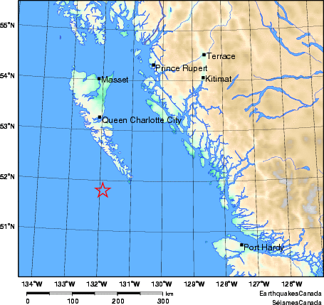
| Latitude: | 51.8 North |
| Longitude: | 131.9 West |
| Depth: | 20.0 km |
| UT Date and Time: |
2009/11/17 18:30:00 UT |
Did you feel it?
Approximate Location of Earthquake: A magnitude 6.5 earthquake occurred at 7:30 a.m. PST near the southern tip of Queen Charlotte Islands region. It was felt across the Queen Charlotte/Haida Gwaii and the North Coast (Terrace/Kitimat). There have been no reports of damage. Aftershocks continue at this time - the largest was a magnitude 5.5 that occurred at 7:37 and was felt on the Queen Charlotte Islands.