The Lac Turquoise Fault Scarp
The Lac Turquoise Fault Scarp: Surface Faulting from the Ungava, Québec, Earthquake of 1989
Information sheet prepared in August 1990
Location and Magnitude
- 8.5 km of surface faulting, trends 038°.
- Maximum throw l.8 m on a thrust fault
- Latitude 60.12° North, Longitude 73.60° West
- Mainshock 14:24 UT, 25 December 1989
- Magnitude 6.3 Ms, moment 1.1x10¹⁸ N-m
- Depth < 5 km
- Hypocentre in Canadian Shield

Interesting Features
First earthquake in eastern North America confirmed to have produced surface faulting.
The fault scarp was found on July 17, 1990, by a GSC field party led by R. J. Wetmiller conducting an aftershock survey of the epicentral area. GSC scientists involved were J. Adams, J. Drysdale, M. Lamontagne and R. J. Wetmiller.
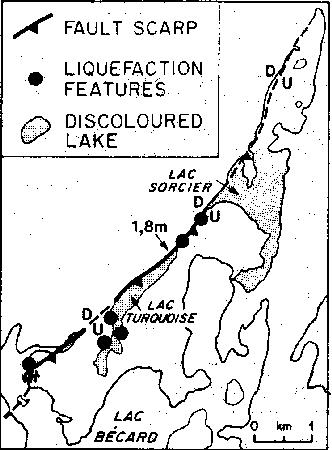
The maximum throw is 1.8 m, along the central 1 km segment.
The throw tapers to less than 0.3 m at each end. The fault trace is concave to the northwest in plan view (see map).
Thrusting on the fault has uplifted lake shorelines, showing the extent and pattern of the vertical deformation. Slip on the fault represents reverse faulting with the southeast side upthrown.
As well as the deformed shorelines, there are fault scarps between adjoining lakes, torn muskeg above some fault traces, sand and mud volcanoes, freshly cracked boulders, a partly-drained lake, a new lake (Lac Sorcier) formed by uplift at the mouth of a bay of Lac Bécard, a left-lateral strike-slip fault, and both new springs and old, dried-up springs. Lac Turquoise and Lac Sorcier are discoloured by suspended silt.
The fault scarp lies in the middle of the unpopulated Ungava Peninsula of northern Quebec and is in the Superior Province (> 2 b.y. old) of the Canadian Shield.
Foreshock 10 hours before the mainshock, magnitude 5.1 (04:25 UT).
There were 5 earthquakes of M>3 between the foreshock and the mainshock, and at least 8 M>3 aftershocks In the two weeks after the mainshock, the largest being magnitude 4.4. Shallow microseismicity continued during the July survey.
For the first time in eastern North America there is the opportunity to compare the extent and magnitude of surface faulting and regional deformation with waveform modeling of the rupture process, and aftershock distribution. The surface effects also suggest the type of evidence to be sought from prehistoric ruptures.
References:
- Adams, John; Wetmiller, R.J.; Hasegawa, H.S; Drysdale, J.A, 1991. The first surface faulting from a historical intraplate earthquake in North America. Nature (London). 352; 6336, Pages 617-619. 1991.
- Bent, Allison. L. 1994. The 1989 (Ms 6.3) Ungava, Quebec earthquake; a complex intraplate event. Bulletin of the Seismological Society of America. 84; 4, 1075-1088.
- Lamontagne, Maurice; Graham, David-F. 1993. Remote sensing looks at an intraplate earthquake surface rupture. Eos, Transactions, American Geophysical Union. 74; 32, Pages 353, 357.