
Frequently Asked Questions about Earthquakes (FAQ)
Table of contents
- Seismic Sources - Earthquakes, Nuclear Blasts, Mining Events
- General
- What is an "earthquake"?
- What causes earthquakes?
- How do earthquakes cause damage?
- Does the earth open up during an earthquake?
- Where do earthquakes occur?
- What is the relationship between volcanoes and earthquakes?
- Will more shocks be felt after a strong earthquake?
- Can earthquakes be predicted?
- Does the rate of earthquakes increase during the cold weather?
- Are there certain months of the year that are more seismically active than others?
- What is the intensity of an earthquake?
- What is a ShakeMap?
- What is a Flinn-Engdahl region?
- Can people cause earthquakes?
- What is an "anthropogenic" seismic event?
- Does a small earthquake mean that a larger earthquake is coming?
- Magnitude
- What is the "magnitude" of an earthquake?
- What is the difference between the "magnitude" and the "intensity" of an earthquake?
- What it is the difference between magnitudes ML and mN?
- Certain earthquakes have a negative magnitude, is this an error?
- Is there a maximum magnitude for an earthquake?
- At what magnitude do earthquakes begin to be felt? When does damage start do to be observed?
- Do several magnitude scales exist?
- Distribution and frequency of Earthquakes
- Global
- In Canada
- Earthquakes in Western Canada
- How often do earthquakes occur in western Canada?
- Have there been damaging earthquakes in western Canada?
- Why are there so many earthquakes in western Canada?
- What are some important studies that tell us about earthquake hazards in western Canada?
- How often do megathrust earthquakes occur?
- How big can they be?
- Where do megathrust earthquakes occur?
- How do we know that megathrust earthquakes have occurred?
- How do we know that we will have another one in the future?
- If the shaking of a magnitude 7 is 10 times greater than a magnitude 6 and 100 times greater
- If a magnitude 6.9 earthquake can devastate Kobe, Japan, what would a magnitude 9 megathrust earthquake do to Vancouver?
- Will Vancouver Island sink when a megathrust earthquake occurs?
- Are megathrust earthquakes our biggest earthquake hazard?
- Why do megathrust earthquakes cause tsunamis?
- Is all of coastal BC vulnerable to tsunamis from a megathrust earthquake?
- What do the different tsunami messages mean ( Warning / Watch / Advisory / Information )?
- If we have lots of little earthquakes will they relieve the stress building up for a megathrust earthquake?
- Where can I find information on Canadian earthquakes?
- In Canada, how many casualties were caused by earthquakes?
- Nuclear Explosions
- Geology (faults, landslides, etc)
- General
- Instruments and networks
- Seismic Hazard and Earthquake Engineering
- Can buildings be designed to withstand earthquakes?
- Are buildings designed to withstand earthquakes in Canada?
- Where can I find information on seismic hazards in Canada?
- Where can I find seismic hazard maps for Canada?
- What is the safest type of structure?
- Where can I get more information on earthquake engineering?
- Facing Earthquakes
- Seismologists
Seismic Sources - Earthquakes, Nuclear Blasts, Mining Events
General
What is an "earthquake"?
An earthquake occurs when rocks break and slip along a fault in the earth. Energy is released during an earthquake in several forms, including as movement along the fault, as heat, and as seismic waves that radiate out from the "source" in all directions and cause the ground to shake, sometimes hundreds of kilometers away.
What causes earthquakes?
Earthquakes are caused by the slow deformation of the outer, brittle portions of "tectonic plates", the earth's outermost layer of crust and upper mantle. Due to the heating and cooling of the rock below these plates, the resulting convection causes the adjacently overlying plates to move, and, under great stress, deform. The rates of plate movements range from about 2 to 12 centimeters per year. Sometimes, tremendous energy can build up within a single, or between neighbouring plates. If the accumulated stress exceeds the strength of the rocks making up these brittle zones, the rocks can break suddenly, releasing the stored energy as an earthquake.
How do earthquakes cause damage?
Most earthquake damage is caused by ground shaking. The magnitude or size (energy release) of an earthquake, distance to the earthquake focus or source, focal depth, type of faulting, and type of material are important factors in determining the amount of ground shaking that might be produced at a particular site. Where there is an extensive history of earthquake activity, these parameters can often be estimated. In general, large earthquakes produce ground motions with large amplitudes and long durations. Large earthquakes also produce strong shaking over much larger areas than do smaller earthquakes. In addition, the amplitude of ground motion decreases with increasing distance from the focus of an earthquake. The frequency content of the shaking also changes with distance. Close to the epicenter, both high (rapid) and low (slow)-frequency motions are present. Farther away, low-frequency motions are dominant, a natural consequence of wave attenuation in rock. The frequency of ground motion is an important factor in determining the severity of damage to structures and which structures are affected.
Does the earth open up during an earthquake?
No! A common misconception is that of a hole in the ground that opens during an earthquake to swallow up unfortunate victims. This has nothing to do with reality but is Hollywood's version of earthquakes. After a strong earthquake, some cracks may be seen on the ground or in basements. These are not faults, nor are they crevasses ready to close up again. Theses cracks are probably due to soil settlement caused by the ground shaking.
Where do earthquakes occur?
Earthquakes occur all over the world; however, most occur on active faults that define the major tectonic plates of the earth. 90% of the world's earthquakes occur along these plate boundaries (that represent about 10% of the surface of the earth). The "Ring of Fire" circling the Pacific Ocean, and including Canada's west coast, is one of the most active areas in the world.
What is the relationship between volcanoes and earthquakes?
The earthquake activity of numerous volcanoes is closely monitored to provide warning signs of an imminent eruption. Large volcanic eruptions, especially the explosive type, can release huge amounts of energy that can be recorded by seismographs even far from the source.
Recent volcanic activity in Canada has been experienced in BC and the Yukon. Worldwide, the majority of volcanoes and earthquakes are located in the same areas. This relationship is explained through a geological model called plate tectonics. You can find additional explanations on plate tectonics:
In Eastern and Northern Canada, earthquakes are not related to volcanic processes. Although volcanic rocks exist in many regions (sometimes as old as 2 billions years of age) and magmatic bodies can be found (the Monteregian Hills of Quebec are 60 million year old intrusives), these magmatic events are just too old to have any relationship with current earthquake occurrences. No volcanic or magmatic activity is currently underway in these parts of Canada.
For more information on volcanoes in Canada, see Volcanoes Canada.
Will more shocks be felt after a strong earthquake?
For several hours, or even days, after a strongly felt earthquake, it is quite possible that people may feel more shocks. This possibility always exists, but keep in mind these four facts:
- In most cases, these shocks (called aftershocks) will be smaller; therefore, the vibrations will be weaker.
- Aftershocks do not mean that a stronger earthquake is coming.
- Aftershocks are normal; they show that the earth's crust is readjusting after the main earthquake.
- The number of felt aftershocks is quite variable and thus cannot be predicted. There might be several per day, or only several per week.
It is impossible to predict either the number or the magnitude of aftershocks that might occur. These vary greatly from one region to another, according to many factors which are poorly understood.
Can earthquakes be predicted?
With the present state of scientific knowledge, it is not possible to predict earthquakes and certainly not possible to specify in advance their exact date, time and location, although scientists have carried out research on a wide variety of attempted prediction methods.
However, the rates of earthquakes in particular regions, expressed in terms of probabilities, can be usefully estimated. Canada, along with other countries, is working to minimize damage and injuries through the implementation of modern earthquake-resistant standards so people will be protected whenever and wherever an earthquake occurs.
Does the rate of earthquakes increase during the cold weather?
Although cold temperatures greatly affect the ground near the surface, it has no effect at greater depths. Near the surface, freeze and thaw cycles can weaken and break rock due to high water pressure. However, this is a phenomenon limited to near surface soil.
Consider a mine: the temperature inside the mine will be influenced by surface temperature only for about the first 50 m. Deeper in the mine the temperature will be influenced by the internal heat of the earth - a temperature that is relatively constant throughout the year.
The hypocentre (the place where displacement occurs along a rock fracture) of an earthquake is generally located several km below the surface (on average, between 5-30 km in Eastern Canada), where the surface temperature would have no influence. For example, the hypocentre of the 1988 Saguenay earthquake occurred at a depth of 28 km where the temperature is approximately constant at 300°C year round.
Furthermore, the principle causes of earthquakes (movement of tectonic plates, volcanoes, etc.) are large scale phenomena, unrelated to surface temperature.
However, close to lakes and rivers, when the ambient temperature drops below -20°C many little microseisms may be heard and are sometimes felt. These microseisms are not earthquakes as they are caused by cracking ice and movements of ice blocks one against another. They are cryoseisms, also known as frost quakes, and can only be felt close to the body of water from which they originate. Such ice cracks can sometimes be detected by a seismograph if it is located close to the body of water.
Seismic trace of a typical frost quake recorded on the vertical component of the seismic station in Sadowa, Ontario, near Georgian Bay (SADO), January 18, 2000 at 6:55 pm, a very cold night (12 frost quakes were recorded within 2 hours that night). A seismologist immediately recognizes the nature of such an event by the single frequency contained in the record.
Are there certain months of the year that are more seismically active than others?
No, there are no months that have more earthquakes than others. Examining the list of Canadian or global earthquakes, there isn't a season that stands out as having an increased number of earthquakes.
The explanation for this can be found by considering that the mechanisms that cause earthquakes are independent of seasonal temperature changes ( see effects of cold temperatures on earthquakes ), and independent of the changes in position of the Earth in the solar system at different times of the year. It is internal geological forces that play the most important role in generating earthquakes.
Most large earthquakes are as a result of immense continental plates, called tectonic plates, that move, one with respect to another. The driving force for this movement is found in the Earth's mantle in the form of convective currents. These currents carry the tectonic plates around the Earth generating earthquakes and volcanic eruptions. The movement of the plates creates strain which is then accumulated in faulted areas causing earthquakes. Both the movement of the plates and the accumulation of strain along faults are continual processes independent of the time of year.
Since the distance between the Earth and Sun changes throughout the year due to the elliptical trajectory of the Earth around the Sun, it seems possible that the attractive gravitational forces between the two bodies might cause extra strain in the Earth's crust. However, strain models have shown that this extra force is insignificant compared to the tectonic force present.
Since the temperature and gravitational forces are the only forces changing with the seasons, seasonal effects can be eliminated as a factor in influencing the frequency of earthquakes.
What is the intensity of an earthquake?
See the Modified Mercalli Intensity Scale.
What is a ShakeMap?
A ShakeMap is a map that shows estimates of how strongly the ground shook during an earthquake. This can help people quickly understand which areas were shaken the most and where damage is more likely. ShakeMaps are produced by NRCan for events near Canada when the magnitude exceeds 4 or it is reported as felt by the public.
The ShakeMap system was developed by the USGS to assess earthquake shaking, in order to estimate potential impacts. The input data include key event parameters (e.g. location, depth, magnitude), models of site amplification, ground motions recorded at seismic stations, and, if available, estimates of ground shaking based on “Did you feel it?” (DYFI) questionnaires submitted by the public (Worden et al., 2020). A ShakeMap can provide valuable information to guide emergency response, especially if combined with reliable data about population density and critical infrastructure. Infrastructure operators with detailed knowledge of the fragility of their installations can use a ShakeMap to accurately predict the impact of an earthquake on those installations (Wald et al., 2021).
ShakeMaps produced by different agencies for the same earthquake can differ for multiple reasons, such as modelling approaches, event parameters, DYFI databases and update timing.
ShakeMaps are automatically-generated models that improve as our understanding of the event improves. The first ShakeMap is typically available within 10 minutes of the event being detected. Subsequent ShakeMaps are generated as refinements are made to the location, depth and magnitude, and as DYFI reports are collected. Although there is no such thing as a “final” ShakeMap, changes are usually minimal after the end of the first normal working day after an event.
For more information, see Worden et al., (2020) and Wald et al., (2021).
What is a Flinn-Engdahl region?
A Flinn-Engdahl region is a standardized, named geographic area, used by scientists to identify quickly where an earthquake happened.
The idea of standardizing regions on a one-degree grid was first proposed by Flinn & Engdahl in 1965 and last revised in 1996, by Young, et al. The boundaries of the regions are angular and don't conform to geological or political boundaries. Nonetheless, the association of an earthquake with a region is computationally efficient, and the regions correctly capture many distinctive tectonic regimes. In fact, ShakeMap uses Flinn-Engdahl regions, combined with other data such as oceanic and stable/active crust boundaries, to determine the tectonic regime of an event (Garcia, Wald & Hearne, 2012).
Although some Flinn-Engdahl regions are named after provinces and territories in Canada, they do not follow the boundaries of their namesakes exactly. For example, part of the Ontario/Quebec border runs north-south at 79.5°W, but the boundary between the Ontario and Quebec Flinn-Engdahl regions runs along 79°W. For a complete list of regions and interactive maps, see the Wikipedia article on Flinn-Engdahl regionalization.
Can people cause earthquakes?
Yes! Minor earthquakes have been triggered by human activities such as mining (rockbursts and cavity collapse), the filling of reservoirs behind large dams, and the injection of fluids into wells for oil recovery or waste disposal. Large dams hold back enormous quantities of water. Some of this water may penetrate into cracks in the underlying rock, and sometimes this may trigger small earthquakes under or very near the reservoir.
Following an underground nuclear explosion, small earthquakes have often been recorded near the test site. These are due to the collapse of the cavity created by the explosion.
Man-made earthquakes always occur close to the site of the activity. There is no link between human activities like these and earthquakes occurring hundreds or thousands of kilometres away.
What is an “anthropogenic” seismic event?
The word “anthropogenic” means that something originates in human activities. Anthropogenic seismic events include those that are induced or triggered by human activities (see above), but it also includes phenomena such as explosions, from quarry and construction blasts to nuclear tests. The main purpose of the National Earthquake Database is to catalogue earthquakes in Canada. Anthropogenic events tend to enter the database when they are difficult to distinguish from earthquakes, are of interest to mine operators, or have research value. Ripple-fired blasts, in particular, are relatively easy to distinguish from earthquakes, based on their waveform characteristics, and are not comprehensively catalogued. It can also be noted that there are some rarer types of “natural” seismic events, other than tectonic earthquakes, such as large landslides and meteorite impacts.
Does a small earthquake mean that a larger earthquake is coming?
No, except for very rare exceptions. Every year, hundreds of earthquakes occur in Canada. Only a very tiny minority of these precede a larger earthquake.
Although a large earthquake may be preceded by a foreshock (the Saguenay earthquake of November 1988 is an example), the occurrence of a small earthquake is not in itself a typical sign. Hundreds of small earthquakes occur every year in Canada, whereas major earthquakes have occurred only a few times in this century.
A small earthquake, however, provides an ideal opportunity to offer reminders about safety measures to take before, during and after an earthquake.
Magnitude
What is the "magnitude" of an earthquake?
Magnitude is a measure of the amount of energy released during an earthquake. It is frequently described using the Richter scale. To calculate magnitude, the amplitude of waves on a seismogram is measured, correcting for the distance between the recording instrument and the earthquake epicentre. Since magnitude is representative of the earthquake itself, there is only one magnitude per earthquake.
Taking the Saguenay QU earthquake of November 25, 1988 as an example, one could not therefore speak of magnitude 6 at Quebec City and magnitude 4 to 5 at Montreal. The effects (or intensities) experienced at different places were different, but the magnitude of the earthquake is unique; in this example, it was 6 on the Richter scale. Magnitude thus has more to do with the effects of the earthquake overall.
The magnitude scale is logarithmic. This means that, at the same distance, an earthquake of magnitude 6 produces vibrations with amplitudes 10 times greater than those from a magnitude 5 earthquake and 100 times greater than those from a magnitude 4 earthquake. In terms of energy, an earthquake of magnitude 6 releases about 30 times more energy than an earthquake of magnitude 5 and about 1000 times more energy than an earthquake of magnitude 4.
It is very unlikely that an earthquake of magnitude less than 5 could cause any damage.
What is the difference between the "magnitude" and the "intensity" of an earthquake?
The Intensity scale is designed to describe the effects of an earthquake, at a given place, on natural features, on industrial installations and on human beings. The intensity differs from the magnitude which is related to the energy released by an earthquake.
What it is the difference between magnitudes ML and mN?
Without going into the seismological details, the magnitude defined by Charles Richter is the source of all magnitude scales. Over the years however, it was realized that the magnitude that Richter had defined for California (ML means local magnitude), did not apply to Eastern North America where the seismic waves attenuate differently. Otto Nuttli, a seismologist at the University of Saint-Louis in the United States, developed a magnitude formula which corresponded better to the reality of Eastern America. One of the formulas which Nuttli derived is used to measure the seisms of Eastern Canada. The formulation used is called Magnitude Nuttli or mN. In order to simplify communication with the public, Canadian seismologists will often refer to the Richter magnitude whereas strictly speaking the seisms that occur in Eastern Canada are measured according to the Nuttli magnitude. An exception exists for the very small earthquakes of the Charlevoix Region, where the Richter scale is used. Around the world other scales of magnitude exist according to the source conditions of the earthquakes (depth), the conditions of attenuation, the type of measured wave, etc. More and more, seismologists describe earthquakes according to the magnitude of the moment scale (MW or M).
Certain earthquakes have a negative magnitude, is this an error?
No, it is not an error. As magnitude calculations are based on a logarithmic scale, a ten-fold drop in amplitude decreases the magnitude by 1. Let us assume that on a seismogram:
- an amplitude of 20 millimetres corresponds to a magnitude 2 earthquake.
- 10 times less (2 millimetres) corresponds to a magnitude of 1;
- 100 times less (0.2 millimetres) corresponds to magnitude 0;
- 1000 times less (0.02 millimetres) corresponds to magnitude -1.
Naturally, a negative magnitude is found only for very small events, which are not felt by humans.
Is there a maximum magnitude for an earthquake?
Though theoretically there is no mathematical limit with the magnitude calculation, physically there is a limit. The magnitude is related to the surface area of the blocks of rock which rub together and in doing so give rise to seismic waves. Since the tectonic plates have finite dimensions, the magnitude must therefore also reach a maximum. It is believed that the greatest earthquakes can reach magnitude 9.5, which corresponds to the magnitude of the Chilean earthquake described below.
At what magnitude do earthquakes begin to be felt? When does damage start do to be observed?
This is difficult to answer absolutely. According to past earthquakes , one can however draw up some general information for Eastern Canada.
Do several magnitude scales exist?
Though seismologists generally refer to magnitude on the Richter scale, several magnitude scales do exist.
Distribution and frequency of Earthquakes
Global
How often do earthquakes occur?
Global Frequency of Earthquakes
Where can I find information on the world's earthquakes?
In addition to the international networks which can detect earthquakes of magnitude 5.0 and greater, the majority of the countries have their own national network.
Are earthquakes really on the increase?
No, earthquakes occur at more or less at the same rate every year. For more info: USGS web site
What was the greatest earthquake in world history?
The greatest earthquake of recent history is the Chilean earthquake of May 22, 1960, which is estimated at magnitude 9.5. According to the USGS, this earthquake caused the death of more than 2000 people in Chile, in addition to generating a tsunami which propagated around the Pacific, adding several hundreds of victims to the assessment. The greatest world earthquakes since 1900 are described on the USGS site.
In Canada
How often do earthquakes occur in Canada?
On average, the Geological Survey of Canada (GSC) records and locates over 4000 earthquakes in Canada each year. That is about 11 per day! Of these 4000, only about 50 (1/week) are generally felt.
Where do earthquakes occur in Canada?
Earthquakes occur across much of Canada. Most earthquakes occur along the active plate boundaries off the British Columbia coast, and along the northern Cordillera (southwestern corner of the Yukon Territory and in the Richardson Mountains and Mackenzie Valley) and arctic margins (including Nunavut and northern Quebec). Earthquakes also occur frequently in the Ottawa and St. Lawrence Valleys, in New Brunswick, and the offshore region to the south of Newfoundland.
- The province in Canada least likely to experience an earthquake is Manitoba.
- The province in Canada most likely to experience an earthquake is British Columbia.
Do damaging earthquakes occur in Canada?
Yes! Some of the world's largest earthquakes have occurred here (see next question).
What is the largest earthquake ever recorded in Canada?
The largest earthquake recorded (during historic times) in Canada was a magnitude 8.1 event that struck just off the Haida Gwaii on Canada's west coast on August 22, 1949. This earthquake (larger than the 1906 San Francisco earthquake) ruptured a 500-km-long segment of the Queen Charlotte fault and was felt over almost all of British Columbia, and as far north as the Yukon Territory and as far south as Oregon State.
Although not recorded by seismographs, the largest earthquake ever to strike Canada was undoubtedly the giant megathrust (subduction zone) earthquake of 1700 off the west Coast of Vancouver Island.
Earthquakes in Western Canada
How often do earthquakes occur in western Canada?
Every day! Scientists at the Geological Survey of Canada office near Sidney, B.C. record and locate approximately 1000 earthquakes each year in western Canada.
Have there been damaging earthquakes in western Canada?
Yes! Some of the world's largest earthquakes have occurred in western Canada. Click here to see the 5 most significant.
Why are there so many earthquakes in western Canada?
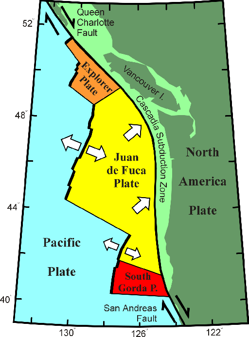
Western Canada is the most seismically active region in Canada. It consists of several discrete areas of intense earthquake activity each corresponding to a particular plate tectonic regime. The most seismic of these regions is offshore, west of Vancouver Island. More than 100 earthquakes with a magnitude of 5 or greater have occurred here in the past 70 years. Most of the seismicity occurs in areas of fractured oceanic crust, which mark boundaries of small plates known as the Explorer and Juan de Fuca plates
Earthquake activity is also high in the Cascadia Subduction Zone. Here, the Juan de Fuca Plate dips below the easterly neighbouring North American plate. Thus, both deep (dipping plate) and shallow (overriding plate) earthquakes occur in this zone, though no earthquakes occur at the interface of the plates. Another region of high seismicity is defined by a zone of plate breakage or "faulting" immediately west of the Haida Gwaii ("the Queen Charlotte fault"). Earthquakes of magnitude 7 occurred here in May of 1929 and June of 1970.
The St. Elias Mountains, southwest Yukon Territory and the extreme northwest of B.C., too, is a highly seismic region. This is because of plate margin deformation between two converging plates in the area (the "Pacific" to the west and "North American" to the east.) Finally, the Canadian Cordillera typically shows intense seismicity north of 60 degrees in a broad zone through the Mackenzie and Richardson Mountains. The largest earthquake recorded here, with magnitude of 6.9, occured in the Mackenzie Mountains in December, 1985. South of 60 N, seismicity drops off markedly away from the coast to a low level through much of the Cordillera, though it is slightly higher in the Coast Mountains from southern British Columbia to the Yukon Border.
What are some important studies that tell us about earthquake hazards in western Canada?
Understanding earthquake hazards involves many types of studies: monitoring earthquakes, monitoring crustal deformation; mapping the marine environment for evidence of offshore earthquake activity; studying wave propagation; mapping earth structure; understanding local geological conditions; and looking for geological evidence of prehistoric earthquakes.
Many different types of studies are conducted by scientists at the Pacific Geoscience Centre of the Geological Survey of Canada to better improve our understanding of earthquake hazards in western Canada.
- Click here for details on monitoring crustal deformation in western Canada
- Click here for details on earthquake-related marine studies
How often do megathrust earthquakes occur?
The recurrence time varies from subduction zone to subduction zone. In the Cascadia subduction zone 13 megathrust events have been identified in the last 6000 years, an average one every 500 to 600 years. However, they have not happened regularly. Some have been as close together as 200 years and some have been as far apart as 800 years. The last one was 300 years ago.
How big can they be?
Megathrust earthquake are the world's largest earthquakes. The last Cascadia earthquake is estimated at magnitude 9. A megathrust earthquake in Chile in 1960 was magnitude 9.5, and one in Alaska in 1964 was magnitude 9.2.
Where do megathrust earthquakes occur?
The Cascadia fault, on which megathrust earthquakes occur, is located mostly offshore, west of Vancouver Island, Washington, and Oregon, although it does extend some distance beneath the Olympic Peninsula of Washington State. The large distance between the Cascadia fault and the urban centres limits the level of shaking that the urban areas are exposed to.
How do we know that megathrust earthquakes have occurred?
The sudden submergence of the outer coast when a megathrust earthquake occurs kills vegetation which can be dated. Megathrust earthquakes also cause underwater landslides off the continental shelf into the deep ocean. The landslide deposits can be recognized in core samples taken from the ocean floor.
How do we know that we will have another one in the future?
The deformation of the crust in a predictable pattern can be detected by very careful geodetic measurements using Global Positioning Satellites, precise levelling, micro-gravity measurements and changing distance measurements using laser technology.
If the shaking of a magnitude 7 is 10 times greater than a magnitude 6 and 100 times greater than a magnitude 5, is the shaking from a magnitude 9 100 times greater than a magnitude 7
No. Earthquake shaking, in the frequencies that damage buildings, increases to a maximum between a magnitude 7 and 8 earthquake, then the shaking simply involves a bigger area. However, the duration of shaking for a megathrust earthquake is much longer. It can be several minutes. This long duration can result in damage to some types of buildings that might not be damaged at the same strength of shaking produced by a smaller earthquake.
If a magnitude 6.9 earthquake can devastate Kobe, Japan, what would a magnitude 9 megathrust earthquake do to Vancouver?
The Kobe earthquake was right beneath the city and the megathrust earthquake will be about 150 kilometres from Vancouver. The damage pattern would be very different. We can get a good example of the kinds of damage Vancouver can expect to experience if we look at what happened to Anchorage, Alaska, during the 1964 magnitude 9.2 megathrust earthquake. Anchorage is about the same distance from the Alaska subduction fault. Small buildings generally had little or no damage, unless they were affected by landsliding. Almost all the damage involved large buildings or large structures such as bridges.
Will Vancouver Island sink when a megathrust earthquake occurs?
No. Vancouver Island is part of the North American plate. The fact that there is water between Vancouver Island and the mainland is function of the current position of sea level. However, the west coast of Vancouver Island will drop as much as a metre or two when the next megathrust earthquake occurs.
Are megathrust earthquakes our biggest earthquake hazard?
No. Inland earthquakes, which are not as big but can be much closer to our urban areas and occur much more frequently, are our biggest earthquake hazard.
Why do megathrust earthquakes cause tsunamis?
The thrusting motion of megathrust earthquake causes large vertical movement on the sea floor and this displaces a large volume of water which travels away from the undersea motion as a tsunami.
Is all of coastal BC vulnerable to tsunamis from a megathrust earthquake?
No. Just the coast exposed to the open Pacific is vulnerable to damaging tsunamis waves. The areas vulnerable to tsunamis are indicated in the red-tabbed pages of the telephone books published for the coastal communities of British Columbia.
What do the different tsunami messages mean ( Warning / Watch / Advisory / Information )?
Data from selected NRCan seismometers are forwarded to the National (United States) Oceanic and Atmospheric Administration’s (NOAA) National West Coast and Alaska Tsunami Warning Centre (NTWC) in Palmer, Alaska. This information is integrated with other seismic, tide gauge, and deep ocean buoy system data to produce tsunami information statements, alerts, watches, or warnings for all North American coastlines (including the Atlantic and Arctic). NTWC distributes these messages to Emergency Measures Organizations (EMO) and other clients 5 to 15 minutes after a potentially tsunamigenic earthquake has occurred and provide updates at regular intervals.
NTWC product definitions are provided here.
If we have lots of little earthquakes will they relieve the stress building up for a megathrust earthquake?
No. It takes many, many small earthquakes to release the amount of energy equivalent to a large earthquake. The amount of energy released increases about 40 times every time there is an increase of one unit on the magnitude scale. Thus, if we consider a small earthquake at the felt level, about magnitude 2, there would have to be 40x40x40x40x40x40x40 of these earthquakes to release the amount of energy as one magnitude 9 event. That is about one million small earthquakes a day, every day, for 500 years. That level of earthquake activity is not observed.
Where can I find information on Canadian earthquakes?
This Earthquakes Canada site is the authoritative source of information on Canadian eathquakes. Available here, among other things:
- A list of events within the last 30 days
- Access to the National Earthquake Database of earthquakes since 1980
- A description of the seismic zones of Canada
- A link to the Pacific Geoscience Centre's Geodynamics prgogram
In Canada, how many casualties were caused by earthquakes?
No casualities were ever directly related to Canadian earthquakes. In fact, Canadian earthquakes have never caused the collapse of a building. Only some injuries were caused by the fall of objects.
Although it has been reported that a yound girl was killed during the 1732 Montreal earthquake, it has never been substanciated by independent sources.
In Canada, the only loss of life related to an earthquake, although indirectly, were those caused by the tsunami created by the 1929 Grand Banks earthquake.
Nuclear Explosions
Can we record nuclear explosions?
Yes! While there are differences between the recordings of an earthquake and a nuclear explosion, the same basic instrumentation and measurement techniques apply. Being geographically the second largest country in the world, Canada plays an important role in nuclear explosion monitoring.
Geology (faults, landslides, etc)
Where can I find information on the faults and the geology of my area?
If you live in the East or the North of Canada, the presence of faults in your area is not indicative of a higher probability earthquakes. In these areas, the faults represent very old geological movements. The Geological Survey of Canada has produced maps for certain areas of Canada. You can consult what is available in the GEOSCAN database.
Instruments and networks
What is a seismograph?
How we record earthquakes - Seismographs
What do seismic waves look like?
How we record earthquakes - Seismic Waves
Is it possible to build your own seismograph?
Building your own seismograph is possible, but it requires time and materials. If your project is due tomorrow, forget about it! If you have a little more time here is a reference:
- " The Amateur Scientist", Scientific American, July 1957 and July 1979: BASIC principles and how to build a simple seismograph.
The 1979 article is reproduced on the Redwood City (California) Public Seismic Network site.
Help on the "See the Shaking" seismogram viewer
The seismogram viewer is a display of vertical component seismic data recorded by a selection of our seismograph stations. It is intended to provide qualitative information for the general public.
The time shown is Coordinated Universal Time (UTC). The plots are delayed by about 5 minutes which is the time it takes to acquire the data and process it.
A pink display indicates that there is no data available for that station at that time.
The vertical scale has been adjusted to a level intended to suppress most local noise and emphasize Canadian earthquakes. There is no simple correspondence between amplitude on the real-time seismogram viewer and earthquake magnitude, as it depends on the distance to the earthquake and other factors. Some recordings which can look quite large are actually just noise such as wind or human activity close to the seismograph station. See Interpreting Seismograms.
If you require detailed technical information, you can download waveforms from our waveform archive; however, using and interpreting the data may require specialized seismological software and expertise.
To find the magnitude of events, you can look at our recent significant earthquake reports and at the the last 30 days of Canada earthquakes.
Seismic Hazard and Earthquake Engineering
Can buildings be designed to withstand earthquakes?
Yes! Engineers can, and are, designing earthquake-resistant structures.
Are buildings designed to withstand earthquakes in Canada?
The first seismic hazard maps for use in Canada have been in use since 1953. This initial hazard map was a subjective assessment based on historical seismicity. In 1970 the first modern maps were developed using probabilistic methods. In 1985 two maps were produced, "acceleration" - suitable for use when designing small structures, and "velocity" - suitable for use when designing large structures.
Where can I find information on seismic hazards in Canada?
Where can I find seismic hazard maps for Canada?
Seismologists at the Geological Survey of Canada produce seismic hazard maps for use in the National Building Code of Canada.
- For more details, to see the maps, or for a detailed reference to the National Building Code of Canada, click here: Earthquake Hazard
What is the safest type of structure?
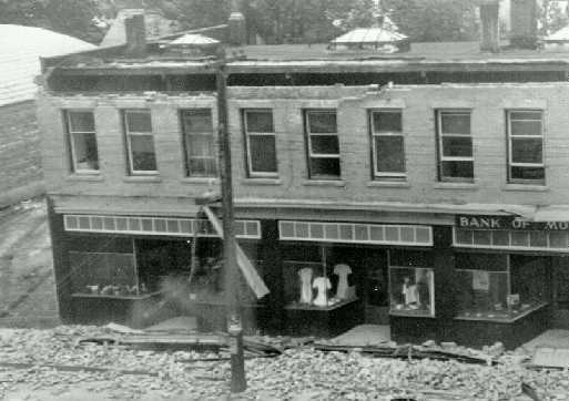
The safest type of structure is a modern, well-designed, and well-constructed building. Generally, wood-frame houses perform very well during an earthquake. However, even these structures are prone to damage from soil failure, chimneys may be damaged or collapse, windows may break, interior walls may crack, and those houses not securely bolted to their foundation may fail at or near ground level. For more information on your home and earthquakes, click here. For some examples of damage to typical wood-frame houses during the M=7.3 Vancouver Island earthquake of 1946, click below:
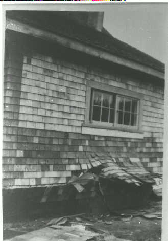
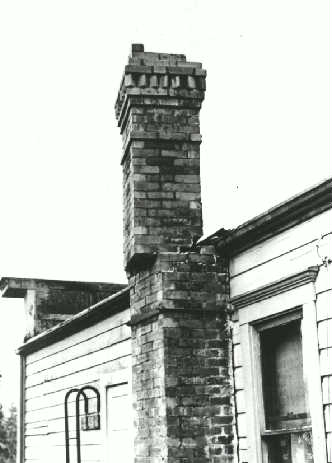
Unreinforced masonary structures (those not seismically upgraded) are generally more vulnerable to earthquake damage. For some photos of damage caused to unreinforced masonary structures during the M=7.3 Vancouver Island earthquake of 1946, click below:
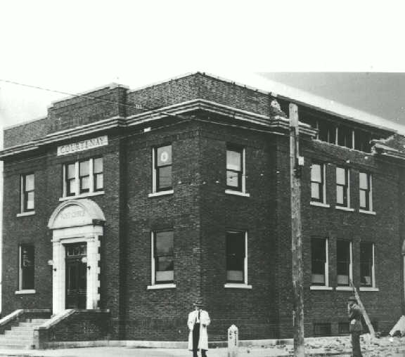
Where can I get more information on earthquake engineering?
- Ottawa Carleton Earthquake Engineering Research Centre
- Pacific Earthquake Engineering Research Center - UC Berkeley
- Multidisciplinary Centre for Earthquake Engineering Research
Facing Earthquakes
What should you do during an earthquake?
Falling objects pose the greatest danger during a major earthquake. In Canada, no house has ever collapsed during an earthquake. However, many types of objects may fall and cause damage or injuries. Of prime concern, therefore, is protection from falling objects such as framed pictures, light fixtures, plaster from ceilings or the upper part of walls, or chimneys which may fall outside or through the roof into the house.
Here is what to do:
- Stay calm - don't panic.
- If you are indoors, stay there. Do not run outside: you could be hit by flying debris or bits of glass. Take cover under, and hold on to a sturdy desk, a table, or a bed - or stand in a doorframe. Never use the elevators (they may have been damaged and/or the power may fail).
- If you are outdoors, stay there. Keep away from power lines and buildings. (House chimneys are likely to topple during a strong earthquake).
- If you are in a vehicle, stop and park away from buildings, bridges and overpasses.
To learn more about earthquake preparedness, follow the links at Preparing for earthquakes.
What should you do after a strong earthquake?
- Stay calm.
- Help the injured, if any. Speak calmly with family members, especially children about what has just happened, in order to relieve stress.
- Stay tuned to the radio and follow instructions.
- Use the telephone only in an emergency.
- Do not enter damaged buildings.
- To prevent fire, check the chimneys or have them checked before using the furnace or fireplace. Check all gas lines.
- Earthquakes can trigger huge ocean waves called tsunamis. The best warning is the earthquake itself and residents in tsunami risk areas should be prepared to evacuate to higher ground immediately (at least 10 metres above sea level) in the case of a large undersea earthquake. Stay tuned to your radio during a disaster.
For more information on earthquake preparedness and what to do during and after earthquakes, follow the links at Preparing for earthquakes.
What causes damage?
Most earthquake damage is caused by ground shaking. The magnitude or size of an earthquake, distance to the earthquake focus or source, type of faulting, depth, and type of material are important factors in determining the amount of ground shaking that might be produced at a particular site. Where there is an extensive history of earthquake activity, these parameters can often be estimated.
The magnitude of an earthquake, for instance, influences ground shaking in several ways. Large earthquakes usually produce ground motions with large amplitudes and long durations. Large earthquakes also produce strong shaking over much larger areas than do smaller earthquakes. In addition, the amplitude of ground motion decreases with increasing distance from the focus of an earthquake. The frequency content of the shaking also changes with distance. Close to the epicenter, both high (rapid)and low (slow)-frequency motions are present. Farther away, low-frequency motions are dominant, a natural consequence of wave attenuation in rock. The frequency of ground motion is an important factor in determining the severity of damage to structures and which structures are affected.
Can houses withstand earthquakes?
Generally speaking, Canadian wood-frame houses are well able to withstand vibrations generated by earthquakes - even very large ones. Moreover, modern buildings must be designed according to national or provincial building code standards, which are intended to minimize the probability of building collapse in major earthquakes.
However, building codes do not prevent certain types of non-structural damage. Thus, it is possible that cracks may be seen on some walls. Unreinforced masonry (e.g. brick walls and chimneys) has little resistance to strong horizontal shaking and may collapse. Vibrations may also cause ground settlement under a house. Sometimes this may cause small cracks in the basement or warping of walls. These are indirect effects that do not indicate that a fault lies near the house.
For more on the effects of earthquakes on buildings, see section 4 above, "Seismic Hazards and Earthquake Engineering." See also How would your home stand up?
Seismologists
What is a seismologist?
What do scientists do after an earthquake?
In the hour immediately following a relatively large earthquake, GSC Seismologists locate the earthquake and measure its magnitude. They use data supplied by the national seismograph network, which feeds continuous data 24 hours per day to the Ottawa and Sidney, BC offices. They pass this information on to the federal Office of Critical Infrastructure Protection and Emergency Preparedness, Provincial Emergency Program offices, to the news media - and, in Quebec, to the Quebec Provincial Police and to Hydro-Quebec.
During the following hours, the seismologists decide whether it would be feasible to conduct a field survey to learn more about the geological environment where the earthquake occurred, and to record any aftershocks that might occur in the ensuing hours and days.
In a field survey, seismologists set up portable seismographs to measure any further release of energy through small earthquakes. This information is analyzed in the weeks and months after the main earthquake and permits scientists to better understand the phenomenon of earthquakes in Canada. In the short term, this information cannot be used to predict earthquakes. In the long term, it will provide the basis for a more comprehensive understanding of seismic activity in the region.
Also, if the earthquake was large, other scientists specializing in surface deposits (clay, sand) may join the field survey team. Engineers may also come to inspect buildings to better determine the effects of the earthquake. Some of these specialists may return again after several months to gather additional data.